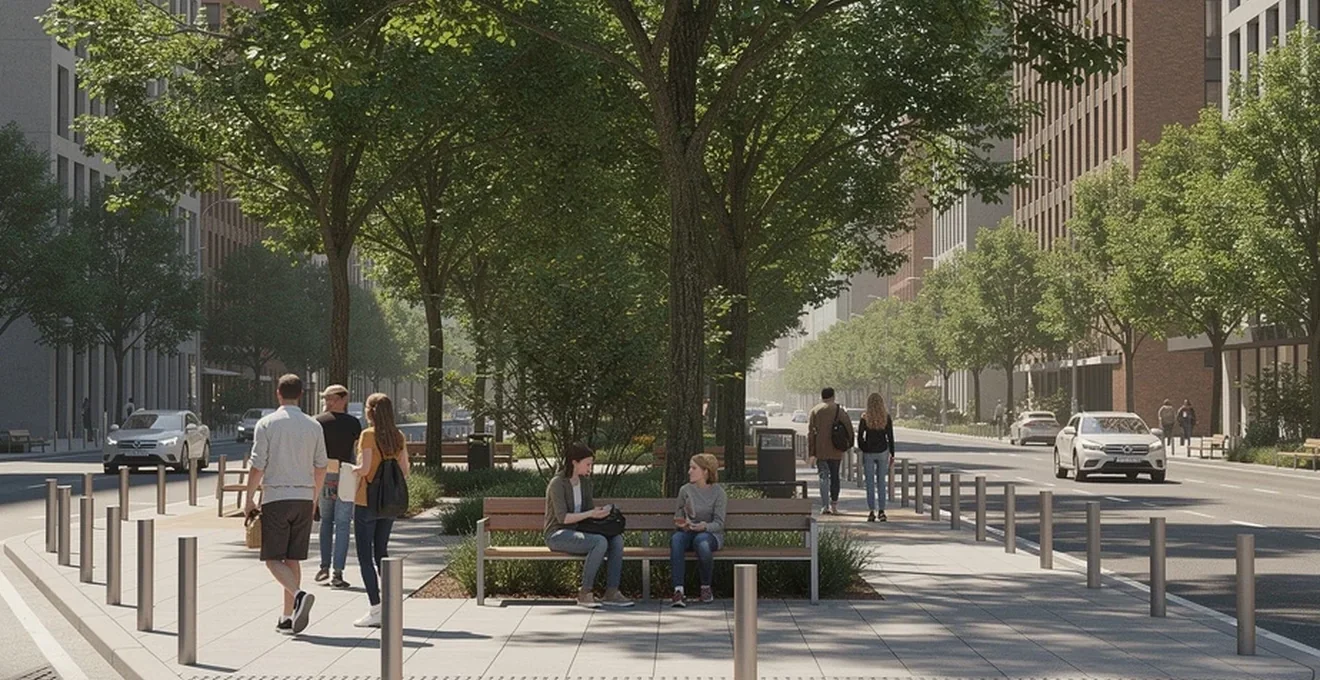
Walking through a well-designed city street feels effortless: there’s shade when the sun is high, a bench when your legs tire, and clear signage pointing you where you need to go. Achieving that comfort is far from accidental. It requires deliberate attention to microclimate, traffic behaviour, street furniture and accessibility, all woven together within a coherent policy framework. As cities move away from car-centric planning, understanding the specific design principles that make pedestrian areas genuinely comfortable has become essential for planners, architects and local authorities alike. This article examines the practical measures behind comfortable pedestrian environments, from tree canopy placement and wind mitigation to wayfinding systems and funding models, drawing on examples from cities that have already put these principles into practice.
Microclimate design principles for pedestrian comfort
Thermal comfort is one of the most overlooked yet influential factors in whether people choose to walk. A street can be beautifully paved and well connected, but if it becomes an oven in summer or a wind tunnel in winter, pedestrians will avoid it. Microclimate design addresses these conditions directly, using vegetation, materials and geometry to keep street-level conditions liveable throughout the year.
Solar radiation management through strategic tree canopy coverage
Trees do more than beautify a street; they actively regulate temperature by intercepting solar radiation before it reaches the pavement. Consistent canopy coverage along a walking route reduces surface heat build-up and creates shaded corridors that make summer walking bearable. As a general principle for street greenery, planners are advised to introduce street trees or other green features at regular intervals, roughly every 15 to 20 metres, so that shade and softening of the urban landscape are distributed evenly rather than concentrated in isolated pockets.
Beyond shade, greenery contributes to how attractive a street feels overall, which in turn influences whether people choose to walk it. Combining canopy trees with lower planting can also help absorb pollutants and dampen noise, adding further comfort benefits beyond temperature control.
Wind tunnel effects between High-Rise corridors and mitigation techniques
Tall buildings positioned close together can create accelerated wind corridors at street level, a phenomenon that makes pedestrian areas uncomfortable and, in extreme cases, unsafe. While the source material does not detail specific wind engineering techniques, the same principles that guide solar and thermal design apply: strategic placement of vegetation, varied building setbacks and street furniture can all serve as windbreaks, softening the impact of these corridors on people walking below. Any pedestrian-friendly design needs to treat wind exposure as seriously as sun exposure, since both directly affect how long someone is willing to linger in a space.
Urban heat island reduction using permeable paving and reflective surfaces
Hard, dark surfaces absorb and radiate heat, intensifying the urban heat island effect that makes cities noticeably warmer than surrounding rural areas. Green corridors and parks help counter this by improving air quality and reducing that heat build-up, offering pedestrians a genuine refuge from the built environment. The High Line in New York City illustrates how repurposing infrastructure, in this case a disused elevated railway, into a green public walkway can simultaneously cool a stretch of the city and encourage people to walk and gather.
Good drainage and shade are not just about aesthetics either; they are functional necessities. Streets that manage rainfall effectively and provide shelter from heat encourage people to choose walking over driving, even when weather conditions are not ideal.
Seasonal thermal comfort modelling with UTCI (universal thermal climate index)
Comfortable pedestrian design must account for how conditions shift across the seasons, not just at a single point in time. Planners increasingly rely on simulation tools to test how proposed street layouts perform under varying conditions before construction begins. Software such as PTV Viswalk allows planners to trial different configurations digitally, identifying bottlenecks and testing signal or layout changes without the cost or risk of real-world trial and error. As Tobias Kretz, a Product Manager at PTV Group, puts it, simulated pedestrians « will not complain when an idea that initially seemed plausible, doesn’t work as planned », underlining the practical value of modelling before implementation.
Traffic calming measures and shared space interventions
Comfort for pedestrians is inseparable from safety, and safety is largely determined by how vehicles behave nearby. Traffic calming measures slow cars down and reduce their dominance of the street, creating conditions in which walking feels natural rather than risky.
Woonerf model implementation inspired by dutch urban planning
The Dutch approach to shared streets, where pedestrians, cyclists and vehicles coexist without strict separation, has influenced pedestrian design far beyond the Netherlands. In shared road spaces, no single group is given clear priority, which counterintuitively tends to improve safety: without dedicated lanes and rigid rules, all road users must pay closer attention to one another. This model suits slow-moving, low-volume traffic conditions particularly well, though it remains a genuinely debated approach. It allows pedestrians to take the most direct route without detouring to formal crossings, but some planners argue it may be less safe than fully pedestrianised zones. Choosing where this model is appropriate, and where it is not, is one of the more delicate tasks mobility planners face.
Raised pedestrian crossings and continuous footway design standards
Physical interventions that visually and physically prioritise pedestrians over vehicles are central to traffic calming. Raised crosswalks force drivers to slow down at the point where pedestrians are most vulnerable, while curb cuts and gradual ramps support wheelchair users and those with pushchairs, ensuring accessibility is built into the crossing itself rather than treated as an afterthought.
Speed reduction through chicanes, bollards and narrowed carriageways
Narrowed streets, speed bumps and similar physical constraints reduce vehicle speeds by design rather than relying solely on signage or enforcement. Lower speed limits make a measurable difference to pedestrian safety: for streets carrying high pedestrian volumes, limits of 10 to 15 mph combined with speed-restricting infrastructure are recommended. Removing blind corners so that pedestrians can see oncoming traffic, and ensuring adequate sight lines generally, complements these physical measures by improving mutual visibility between drivers and walkers.
Barcelona’s superblock (superilles) strategy for traffic diversion
Barcelona’s superblocks reorganise groups of city blocks to prioritise pedestrians, reduce traffic congestion within the block, and expand green space. The approach has proven effective at reclaiming space for people, but it comes with a notable trade-off: redirected traffic can increase congestion in the surrounding streets that were not converted into pedestrian zones. This has been observed directly in Barcelona’s superblocks, where vehicle flow displaced from the pedestrianised core adds pressure elsewhere. The lesson for other cities is that pedestrianisation cannot be treated as an isolated, block-by-block exercise; it needs to be paired with broader strategies that reduce overall vehicle volumes, such as congestion charging, improved public transport and car-sharing schemes, so that the benefit of one area does not simply become a burden on another.
Street furniture and Human-Scale infrastructure placement
Comfort is often decided by small, human-scale details: whether there’s somewhere to sit, whether a bench is too hot to touch in summer, whether the lighting makes you feel safe after dark. These elements are frequently the difference between a street people merely pass through and one they choose to spend time in.
Bench spacing guidelines based on elderly mobility research
Seating is not a luxury addition to a pedestrian street; it is a safety feature, particularly for elderly people and others with limited mobility who need to rest at predictable intervals. On busy streets, the recommended benchmark is seating provided at least every 100 metres, allowing people to pace their journey without fear of being caught without a place to rest. This spacing also supports families with small children and anyone managing a chronic illness, making the street usable across a far wider range of the population.
Public seating materials for thermal comfort in varying climates
The material a bench is made from affects how comfortable it is to use across different weather conditions, tying seating design back into the broader microclimate considerations discussed earlier. Seating also does more than provide rest: well-positioned and well-designed benches, along with informal seating options such as low walls and planters, can encourage social interaction and give people a genuine reason to linger rather than simply pass through. This is one of the recognised indicators of a « healthy street », where having things to see and do, combined with comfortable places to pause, directly improves how walkable a route feels.
Lighting design standards for nighttime pedestrian safety perception
Perceived safety after dark depends heavily on lighting quality. Street lighting should illuminate the full walking space, not just the carriageway, since pedestrians navigating dimly lit footways are far more exposed to both traffic risk and personal safety concerns. Smart street lighting technology adds a further layer of capability, with some systems able to respond dynamically, for instance by brightening when pedestrians are detected approaching a crossing, contributing to a safety strategy that is proactive rather than purely reactive.
Wayfinding systems and sensory accessibility enhancements
A comfortable pedestrian area is also an intuitively navigable one. Confusion about where to go, or an inability to safely process cues in the environment, undermines comfort just as much as poor paving or lack of shade.
Tactile paving integration for visually impaired navigation
Accessibility is a foundational requirement of pedestrian zone design, not an optional extra. Tactile paving and ramps allow people with visual impairments and wheelchair users to navigate confidently, while pedestrian signals incorporating auditory cues and countdown timers ensure that crossing points are genuinely safe for everyone, not just those with full sight and mobility. Addressing uneven surfaces and inadequate signage is essential to making these zones truly inclusive, since even small oversights can exclude significant parts of the community.
Legible london signage model for intuitive urban navigation
Clear signage and wayfinding systems help pedestrians reach their destinations efficiently and reduce the low-level stress of feeling lost in an unfamiliar area. As a general guideline, wayfinding signs should appear at least every 100 to 200 metres, giving people frequent enough reference points to stay oriented. Beyond simple directional information, wayfinding can also be used to provide deeper context about local culture and history, connecting pedestrians to the character of the area they are walking through rather than treating navigation as a purely functional task.
Acoustic design considerations to reduce ambient noise pollution
Reduced vehicle traffic in pedestrianised areas brings a direct acoustic benefit: fewer engines and less congestion mean quieter streets, alongside the well-documented air quality improvements. This reduction in ambient noise contributes meaningfully to the overall comfort of a space, making it easier for people to hold conversations, relax, or simply enjoy their surroundings without the constant backdrop of traffic noise that characterises car-dominated streets.
Case studies from leading Pedestrian-Friendly cities
Examining how specific cities have approached pedestrianisation offers practical lessons that go beyond theory, showing what works, what creates friction, and how long-term commitment pays off.
Copenhagen’s strøget pedestrian street transformation since 1962
Strøget in Copenhagen is widely regarded as one of the first major European pedestrian streets, established in 1962. Its transformation did more than remove cars from a single street; it helped cultivate a broader walking culture in the city and served as a prototype that has since inspired pedestrianisation efforts worldwide. Copenhagen’s long-standing investment in extensive bike lane networks and public transport has made car use largely unnecessary for many residents, demonstrating how sustained infrastructure investment, rather than a single intervention, is what ultimately shifts a city’s relationship with walking and cycling.
Pontevedra’s Car-Free city centre model and metropol parasol comparison
Spanish cities have produced some of the more striking examples of pedestrian-focused urban renewal. The conversion of Bogotá’s Carrera Séptima into a pedestrian-friendly area, for instance, increased local business revenues and improved community engagement, illustrating that removing cars from a commercial street does not necessarily harm local trade, and can in fact strengthen it. More broadly, research into pedestrian zones has found property values and business attractiveness increasing by between 20 and 70 percent in areas converted to pedestrian use, a range that underscores how significant the economic upside of well-executed pedestrianisation can be.
Melbourne’s laneway revitalisation through active frontage policy
Melbourne’s Bourke Street Mall demonstrates how pedestrian zones can successfully integrate public transport rather than excluding it entirely. By balancing accessibility with car-free space, the mall has enhanced both foot traffic and retail opportunities, showing that pedestrianisation does not have to mean a total ban on all vehicles; it can instead mean a careful hierarchy that keeps essential transport links running while still giving pedestrians clear priority over private cars.
Policy frameworks and funding mechanisms for implementation
None of these design measures materialise without political backing, funding and a coherent strategy to guide implementation. Turning good ideas into built infrastructure is often the hardest part of the process.
Vision zero integration with pedestrian priority zoning
Clear, measurable objectives give a pedestrian strategy direction and accountability. Vienna’s 2014 pedestrian strategy is a useful example, setting out targets such as decreasing traffic accident victims by 5% annually and increasing the pedestrian share of all trips taken across the city. Objectives of this kind need to be paired with concrete short and long-term actions, aligned with the city’s annual budget, and might include both infrastructural changes and education or awareness campaigns. Establishing targets that are specific, measurable, achievable, relevant and timely allows a city to properly evaluate and review its strategy later, rather than treating it as a one-off document.
Tactical urbanism pilot projects for Low-Cost community testing
Rather than committing to large, irreversible infrastructure changes from the outset, many cities test ideas first through low-cost, temporary interventions. Paris has used tactical urbanism in exactly this way, temporarily transforming car parking spaces into pedestrian-friendly areas to test their effectiveness before deciding on permanent adoption. Trondheim’s walking strategy team followed a similar logic, beginning with pilot projects rather than a finished plan. As Birgit Hoyland, who oversees walking projects at Miljøpakken (Greener Trondheim), explains, the city’s walking strategy « started because we had some pilot projects. It was very eye-opening. » This step-by-step approach, testing what works and adjusting according to public feedback, tends to build stronger public trust than presenting a finished strategy with no opportunity for course correction.
Community involvement should ideally begin even earlier than the piloting stage, informing which interventions are worth testing in the first place. José Besselink, urban planner and chief editor of Rotterdam’s walking strategy, emphasises this point directly:
« involving local communities is very important. Have their expertise linked to your policy and involve as many people as possible to create the importance in the city ».
Rotterdam also used external expertise to build momentum for its strategy, hosting the Walk21 conference in 2019 as what Besselink describes as « a tool to plant the seed in our colleagues’ heads and draw from it afterwards ».
Public-private partnership models for streetscape regeneration funding
Funding remains one of the most persistent obstacles to pedestrian zone development, since infrastructure changes, ongoing maintenance and traffic rerouting all carry real costs. Public opposition frequently compounds this challenge, particularly from businesses concerned about losing vehicular access and passing trade, even though evidence from cities such as Bogotá suggests these fears are often unfounded once a scheme is established. Successfully securing funding and support tends to depend on tailoring the argument to the audience: traffic engineers, councillors and health officials may respond to different points than local traders, commuters or elderly residents. Taking an integral approach, one that connects walking policy to health, education, transport and finance departments rather than treating it as a mobility issue alone, helps build the breadth of institutional support needed to secure funding and see a strategy through from proposal to implementation.